
What is remote sensing
Remote sensing is the method of acquiring information about an object or phenomenon without making physical contact with the object and thus opposite to in situ observation. In day to day use, the term generally refers to the use of aerial sensor technologies to detect and classify objects on Earth (on the surface, atmosphere and oceans) by means of transmitted signals (e.g. electromagnetic radiation). It may be split into active remote sensing, when a signal is first emitted from system which supplies its own energy source like aircraft or satellites) or passive (e.g. sunlight) when information is merely recorded.
It can also be defined as a means acquiring information about an object or phenomenon from a distance, i.e. without actually coming in contact with the object.
or
“the art, science, and technology of obtaining reliable information about physical objects and the environment, through the process of recording, measuring and interpreting imagery and digital representations of energy patterns derived from noncontact sensor systems”.
Types of remote sensing
Active Remote Sensing – An active Remote Sensing system supplies its own source of energy, which is directed at the object in order to measure the returned energy.
Active Sensors – RADAR, LIDAR
Passive Remote Sensing – Makes use of sensors that detect the reflected or emitted electro-magnetic radiation from natural sources.
Passive Sensors – Landsat
How remote sensing works?
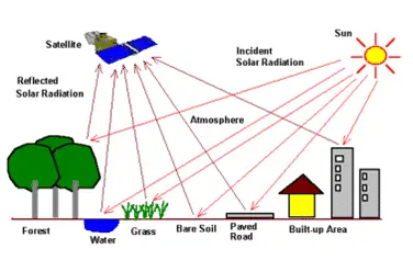
In remote sensing, a detector measures the electromagnetic (EM) radiation that is reflected back from the Earth’s surface materials. These measurements can help to distinguish the type of land covering. Soil, water and vegetation have clearly different patterns of reflectance and absorption over different wavelengths.
![]() The Electro-Magnetic Radiation(EMR), which is reflected or emitted from an object, is generally the source of remote sensing data. However, other mediums such as gravity or magnetic fields can also be used in remote sensing in addition or as substitute to EMR
The Electro-Magnetic Radiation(EMR), which is reflected or emitted from an object, is generally the source of remote sensing data. However, other mediums such as gravity or magnetic fields can also be used in remote sensing in addition or as substitute to EMR
![]()

Process:
- Energy Source or Illumination
- Radiation and the Atmosphere
- Interaction with the Target
- Recording of Energy by the Sensor
- Transmission, Reception, and Processing
- Interpretation and Analysis
- Application
Read about: GIS Softwares, Who uses GIS, Use of GIS application